Trip:
Lima, Peru
Trip:
Lima, Peru
Users' blogs about Lima (Peru)
This is our users' travel blog about Lima, Peru. Here you'll find hostels and hotels reviews, suggestions for bars and restaurants, or any other recommendation that young travelers may want to share about Lima, Peru. All users can publish on this page, just for their friends or for everyone. To enjoy exclusive contents or publish your own, join MyClub network right now! (If you already have a Facebook, Google or Twitter account it's just a matter of few clicks).
NOT REGISTERED YET? Sign Up Now
Sign in using one of your accounts
As we sit in a small Miraflores studio apartment, I hear sounds of lively street full of small cars, mopeds and trucks rushing passed our window. With rapid bursts of signaling constantly persuading ...
over 9 years ago
Trip:
Lima, Peru

Axel Tippe
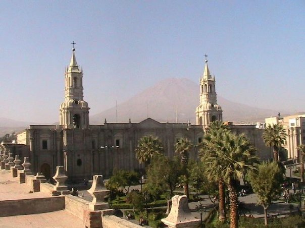
Lima ( City of The Kings ) Paracas ( Ballestas Island ) Nasca ( Nasca Lines ) Arequipa ( Colca Canyon ) Puno ( Titicaca Lake ) Cusco ( Surronding & Machupicchu )
over 10 years ago
Trip:
Peru 15 Days
Axel Tippe
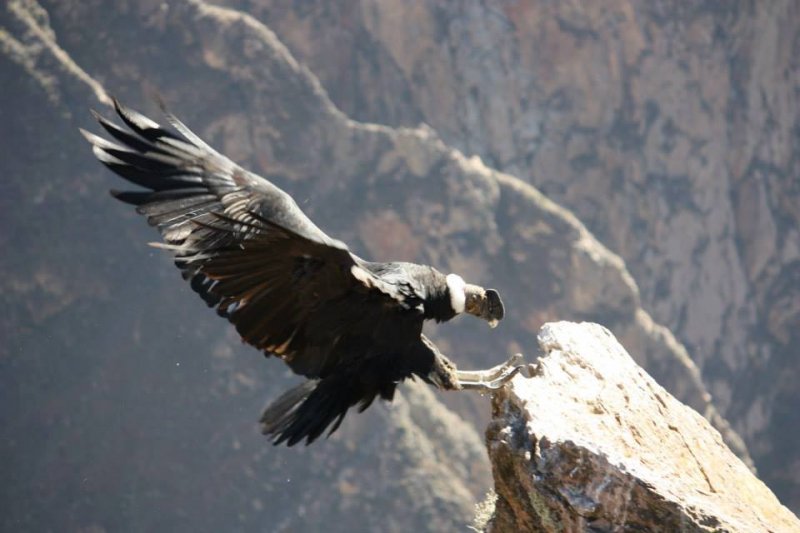
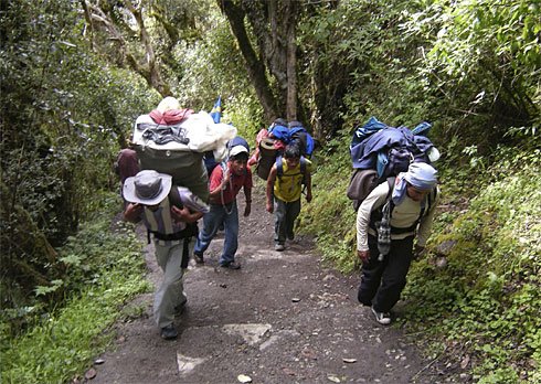
The Inca Trail is Peru's best known hike, combining a stunning mix of Inca ruins, mountain scenery, lush cloud-forest and rich subtropical jungle. Over 250 species of orchid have been counted in the Machu Picchu Historic Sanctuary, as well as numerous birds such as hummingbirds, waterfowl and the majestic Andean Condor. The star of the Sanctuary is the spectacled bear - a shy, herbivorous animal that is extremely rare and close to extinction.
Essentially the Inca Trail is a mountainous jungle hike leading to the sacred Inca city of Machu Picchu. The 45km trek is usually covered in 4 days, arriving at Machu Picchu at daybreak on the final day before returning to Cusco by train in the afternoon.
The trek is rated moderate and any reasonably fit person should be able to cover the route. It is fairly challenging nevertheless, and altitudes of 4200m are reached, so ensuring that you are well acclimatized is important. If arriving from sea level, plan to spend at least 2 full days in Cusco (3 days is better) prior to commencing the trek. This should allow plenty of time for acclimatization and give you sufficient opportunity to visit the City of Cusco and nearby Inca ruins at Sacsayhuaman, Quenqo, Puca Pucara & Tambomachay s well as spending a day or two exploring the Sacred Valley of The Incas visiting the tradition market town of Pisac and the fascinating Inca fortress at Ollantaytambo
over 10 years ago
Trip:
Peru 15 Days

Axel Tippe
Peru & Bolivia 15 Days
Incl. Inca Trail to Machupicchu
Lima ( City of The Kings ) Paracas ( Ballestas Island ) Nasca ( Nasca Lines ) Arequipa ( Colca Canyon ) Puno ( Titicaca Lake by Catamaran in Bolivia Side) Bolivia ( La Paz City + Tiawanaku ) Cusco ( Surronding & Inca Trail Machupicchu 04 Days / 03 Nights ) Axel Tippe WWW.AXELTOURS.COM WWW.PERUTOURISTINFORMATION.COM
WWW.FACEBOOK.COM/PERUTOURISTINFORMATION
WWW.ECUADORTOURISTINFORMATION.COM WWW.FACEBOOK.COM/ECUADORTOURISTINFORMATION
Skype. Machupicchu10

over 10 years ago
Trip:
Peru 15 Days
Axel Tippe
Nazca Lines 460 kms from Lima 8 hrs by bus
The Nazca Lines are a series of ancient geoglyphs located in the Nazca Desert in southern Peru. They were designated as a UNESCO WORLD HERITAGE SITE in 1994. The high, arid plateau stretches more than 80 kilometres ( 50 mi ) between the towns of Nazca and Palpa on the Pampas de Jumana about 400 km south of Lima. Although some local geoglyphs resembleParacas motifs, scholars believe the Nazca Lines were created by the Nazca Culture between 400 and 650 AD. The hundreds of individual figures range in complexity from simple lines to stylized Hummibirds, Spiders, Monkeys, Fish, Sharks, Orcas and Lizards. The lines are shallow designs made in the ground by removing the reddish pebbles and uncovering the whitish/grayish ground beneath. Hundreds are simple lines or geometric shapes; more than seventy are Zoomorphic designs of animals such as birds, fish, llamas, jaguar, monkey, or human figures. Other designs include phytomorphic shapes such as Trees and Flowers.The largest figures are over 200 metres (660 ft) across. Scholars differ in interpreting the purpose of the designs, but in general they ascribe religious significance to them. Other theories have been summarized as follows:
"The geometric ones could indicate the flow of water or be connected to rituals to summon water. The spiders, birds, and plants could be fertility symbols. Other possible explanations include: irrigation schemes or giant astronomical calendars. Due to the dry, windless, and stable Climate of the Plateau and its isolation, for the most part the lines have been preserved. Extremely rare changes in weather may temporarily alter the general designs. As of recent years, the lines have been deteriorating due to an influx of Squatters inhabiting the lands.

over 10 years ago
Trip:
Peru 15 Days
Axel Tippe
Holas les invito a visitar mi almbun de fotos referente a mi ultimo viaje por Peru, Ecuador, Bolivia 1.- Israel Friends September 2013 2.- Cuzco / Puerto Maldonado / Rio Branco ( Brazil ) by private car 3.- Ecuador September 2013 4.- Galapagos / Tumbes ( Peru ) 5.- Peru & Bolivia Nov.2013 6.- Waynapicchu / Machupicchu Nov19th,2013 Saludos de Peru La Tierra de Lo Incas gracias por su amistad en FACEBOOK espero ser de gran ayuda tenemos ofertas de viaje en todo Peru, todo turista que vista Peru hace el clasico recorrido El Gringo Trail: Lima ( Ciudad de los Reyes ) Paracas ( Isla Ballestas ) Nazca ( Lineas de Nazca ) Arequipa ( Cañon del Colca ) Puno ( Lago Titicaca ) Cuzco ( Alrededores & Machupicchu o el Camino Inca 04 dias 03 noches ) pero desde el 2012 tenemos un nuevo recorrido que podria ser de su agrado: Navegemos en el rio Amazona : Peru, Colombia & Brazil hacia la ciudad perdida de Los Incas ( Machupicchu ) 20 dias / 19 noches
Axel Tippe
WWW.PERUTOURISTINFORMATION.COM
WWW.FACEBOOK.COM/PERUTOURISTINFORMATION
WWW.ECUADORTOURISTINFORMATION.COM WWW.FACEBOOK.COM/ECUADORTOURISTINFORMATION WWW.AXELTOURS.COM
Skype. Machupicchu10

over 10 years ago
Trip:
Peru 15 Days


 group booking special offers
Travelling in a group? Click on the link below to get the list of hostels that accept reservations for 10 or more guests. Use the search form to check availability and book online. If you like, feel free to contact us at groups@hostelsclub.com, we will help you find the best offer for your group.
Other cities in Peru
Don't miss our offers!
Register your email to receive our monthly newsletter with discounts, special offers and competitions!
|
© HostelsClub.com 2002-2024 |
hostels tours |
About us Help |
Join us Back Office |
my club specials |
Magazine Links |
Jobs credits |
terms of use privacy policy |
|